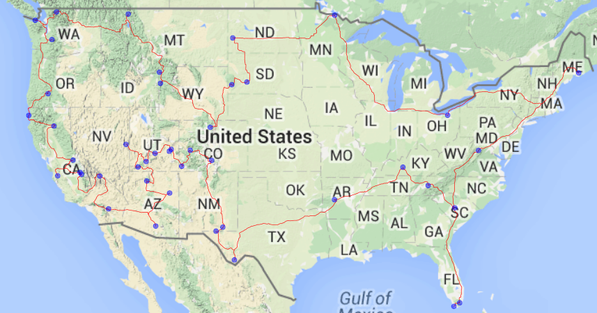
A National Parks Tour With Feather
This year is the 100th Anniversary of the National Park system and the National Park Service is kicking things off with National Park Week where every National Park will be open for free. With all the savings, my next thought was what would be the best way to visit all of them in a single trip?
To calculate this, I used a variant of the Concorde algorithm which is an algorithm for solving the Traveling Salesman Problem or what is the shortest route I can use to visit every National Park?
This also gave me an excellent opportunity to use Feather a way of writing dataframes to disk for interchanging between R and Python. I wanted to use R largely due to Michael Hahsler’s TSP library and I wanted to use python because of the ease of use of the Google Maps API client. Finally, I wanted to make a static map to show the route and I decided return to R and use the ggmap library.
I realize there are many ways to call R from Python and vice versa but I wanted to try feather. As a first attempt, I was pretty impressed with feather’s ease of use. I did not have too large of a dataset so I was unable to comment on the speed but simple reading and writing in R and Python is made to feel very simple. The one issue I did run into was more of a user issue and that it was challenging to rapidly flip back and forth between the two languages as I iterated this code. The 0-index of Python versus the 1-index of R is all handled by feather which is nice not to have to think about.
As a whole, I highly recommend checking out feather and as for me, well its time to hit the road and start visiting some National Parks and according to Google Maps I only have 14832.8 miles to go.
My code for this lives here